Historical Map Comparisons
Selected Mountain Biking Parks in Southwestern Connecticut
Have you ever wondered what a park that you visit might have been like a couple of hundred years ago? These maps and overlays may give you an idea of the starkness of the surroundings and the development that occurred.
The historical topo maps are cropped from the University of New Hampshire's collection. It is an amazing resource! Be sure to visit their collection and learn about other spots as well. (Link at the bottom of this page).
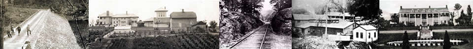
TIP: You can roll over the Masthead above for the photo locations.
* Rich Coffey
Collis P. Huntington State Park
In the late 19th century, Commodore Walther Luttgen (a prominent New York banker, industrialist and yachtsman) built an enormous estate on the land and developed the present day park service roads, trails, and artificial ponds
The estate, including Luttgen's mansion Villa Linta, was acquired upon Luttgen's death in 1922 by Joseph E. Sterrett (a principal with the accounting firm of Price, Waterhouse). After the villa burned down, the land was acquired from the Sterrett family by Archer M. Huntington, the philanthropist stepson of industrialist Collis Potter Huntington. Archer Huntington and his wife Anna Hyatt Huntington moved to the estate, now called Stanerigg, in 1939. Further Details About the Estate >
About the map: Note the northeast diagonal road across the park. Although it doesn't sync up exactly with the overlay (older maps were not as accurate), it corresponds to the current double track in that vicinity.
| 1893 Topo Map with Park Land Defined | 1893 Topo Map Overlaid with Current Park and Trails |
 |
 |
Bennett's Pond - Hemlock HIlls
Bennett's Pond State Park was once the home of Louis D. Conley, a successful manufacturer and nursery man. At a picturesque spot at the top of the hill, Colonel Louis Connolly built a house in the early 1900s and called it Outpost Farm. Shortly thereafter he established the Outpost Nurseries, one of the largest nurseries operating on the east coast which at its peak included 2,000 acres in Ridgefield. His mansion later became the Fox Hill Inn, a famous restaurant from the 1940s till the early 1970s when IBM bought it for a possible corporate site. IBM razed the house in 1974 and, in 1998, sold the land to Eureka, a developing company.
The site is now part of the Bennett's Pond open space. Where the house stood is now a clearing overlooking miles of hillsides. Remnants of the steps and terraces on this lawn can still be seen. Up on Pine Mountain, a chimney still stands, it is all that remains of Charles Ives' get-away shanty.
- Where did those Lakes came from south of Hemlock Hills?
- Further Info on Colonel Louis Connolly >
- Historical Info on the Park >
About the map: This map was created by fusing two adjacent maps, hence the half striped look...
| 1893 Topo Map with Park Land Defined |
 |
| Current Park and Trails Overlay |
 |
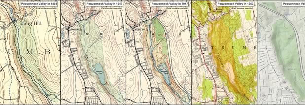
Pequonnock Valley (Trumbull)
Carved from a wild torrent of glacier melt eons ago, the valley has a rugged and varied landscape. Transformed throughout history, in the 18th Century it was once a bustling industrial and commercial landscape. Over the years, nature has reclaimed it and it is now back to its natural habitat: a thriving ecosystem for a variety of plant and wildlife.
Click on the graphic below to view a chronological map display of the valley's transformation through the years.
Historical Maps
- University of New Hampshire's Library's Government Information Department holds a working collection of over 55,000 paper USGS maps. This online collection of over 1,500 USGS topographic maps includes complete geographical coverage of New England and New York from the 1890s to 1950s. Historic USGS Maps of New England & NY - Connecticut