History Tidbits
Burnt Hills, Ballston Lake and Vicinity
I am an admitted info addict and history buff.* Growing up in Charlton and going to school in the BHBL school district, I put this small site together as a tribute to my roots. There is a lot of fascinating history that many folks might not be aware of.
We were fortunate as kids to learn all about the proud Iroquois Nation, the fierce Mohawks and bloodshed with the Dutch settlers in colonial times. Of course, no "upstater" from the area could have avoided the knowledge of the Erie Canal and the vital importance the Mohawk River had in opening up the West to white settlers ("I had a mule her name was Sal... Fifteen Miles on the Erie Canal" was a song so ingrained in our upbringing, we all sang it in our sleep! )
But strangely, less is known about the Amusement Parks and the Train and Trolley Lines. They too were an integral and unique aspect of local history. This site hopes to offer a window into that world and tie it all together. History should never be forgotten. Visiting local Historical Society Archives in person or online provides an entertaining and educational opportunity to go back in time...
* Rich Coffey
Clifton Park | Glenville | Scotia | Schenectady | Ballston Spa | Malta | Alplaus
Burnt Hills
 The small village of Burnt Hills got its unusual name from the practice of the Native Americans. Local tribes would sometimes burn the surrounding hillsides to attract deer who would then venture out to eat the new shoots that would sprout up from the ground. Thus, the area became known as the land of the “Burnt Hills." Further Info
Did You Know?
- BHBL was New York state's first "consolidated" school district. In 1915, three one-room schools were joined to form the "Burnt Hills-Ballston Lake Union Free School District
Ballston Lake
 Ballston Lake, originally called Ball's Town, was named in honor of Rev. Eliphalet Ball. The first settlement was made in 1763 by two brothers named Michael and Nicholas McDonald, who located near the west bank of Ballston Lake. In 1770, Mr. Ball, his three sons and several members of his congregation were induced to settle here from Bedford, N.Y. by a donation of 500 acres of land. It is said, Ball paid the brothers one barrel of rum for the right to name the town after himself. Over time the name was shortened to Ballston.
Did You Know?
- Ballston Lake, was called "Shanantaha" by natives. It was known to early white settlers as Long Lake.
Further Info - Some geologists find evidence that the lake was part of the Mohawk River during the glacial age. Cite
- Carneys' Tavern, once a grocery store, was converted back in 1877 into a ten room hotel named "Shendahora." Further info | Historic Landmark (Daily Gazette)
- The Villago Pizzeria (formerly the Good Times Restaurant) was once a Speakeasy and gambling machines were often dumped in Ballston Lake to hide from police raids. Details
- There was once an amusement park called Forest Park on the Lake. It had a dance hall, picnic grounds, cottages and even a merry-go-round. Ballston Lake and Forest Park Amusement Park Historical Photo Collection (Search: "Ballston Lake NY Forest Park")
Charlton
 Did You Know?
- Charlton, although known as a farming community, once had eight taverns, two sawmills and two gristmills?
- By the mid 1800s it could boast of having in addition: cider mills, a distillery, blacksmiths, tanners, a butter and cheese factory, a few general stores and even several hotels. (Info taken from the Town of Charlton 200th Year Calendar) See a few Historical Photos.
 | Photos and Maps of the Mill Sites
 - That house on the corner of Stage Road and Callagan Blvd was built in 1796 and was once a tavern. In 1831, the owner of this house managed 130 acres of surrounding farmland. In 1952, 3 1/2 acres of that land was sold and converted to a suburban development called “Orchard Grove” and the streets were named after prominent Charlton residents (Callagan, Hawley and Marvin)
- A farm set off of Vines Road in Charlton was once called “Wildcat Alley” and the early owner built a mill on the nearby Alplaus Kill. He also ran a sawmill further west on Swaggertown Road.
- Swaggertown Road was NOT named after a puffy-chested braggart but it was derived from "brother-in-law" in Dutch "zwager"
- More Info on the Tucker Heights area
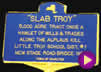 "Slab Troy"
- The short section of Old Stage Rd., from Stage Rd. to the abandoned Little Troy Bridge, was the once the site of several mills. The location was known as Slab Troy (or Little Troy) and during the years from 1820 to 1830, it had a blacksmith-shop, a fulling-mill, and carding-machine, a grist-mill, a saw-mill, a store, a tavern, and three distilleries! Sadly by 1878, not one of these commercial establishments were left.
- The old school house is now converted to a house [my older sister remembers spending her first year of school there].
 "Slab Troy"
About the Charlton Girls School...
- The Charlton Girls School was originally started as a "home for wayward and homeless boys". It was called "The Charlton Industrial Farm School for Boys" and it officially opened in 1895.
- On April 2, 1938 the whole place burned down and it wasn't until 1954 that it reopened again as a school for girls.
- Read all about its history here
Round Lake
 Did You Know...?
- Round Lake was started as summer religious camp for Methodists with as many as 20,000 gathering to hear rousing summer sermons. Link
- Round Lake has the oldest and largest Tracker organ in the United States. It is considered to be the oldest and largest three-manual organ in existence. Link
- Round Lake once had on a miniature plot, a scale model of Jerusalem and a topographical representation of the land of Palestine. It was amazing! In 1878 an entrepreneur built a scale model of the holy land on the shore of the lake, including a large diorama of Jerusalem. Visitors could wander around Mount Lebanon and Galilee, and hear one of the two daily lectures at the park. Read about it in an 1878 Newspaper (click "View Full Article" This is a New York Times archive) | Details/Photos
- Round Lake was once home to the the third largest museum in the State: the George West Museum of Art and Archaeology.
More About the History of Round Lake
- Link (scroll to ROUND LAKE. 38)
- 1878 Historical Record
Vischer Ferry
 Have you ever been through this little hamlet? It's a lovely spot and full of old fashioned charm.
Did you know?
- The site became known as Vischer Ferry after Nicholas Vischer's son, Eldert Vischer, opened a rope ferry at the site in 1790.
- As the Erie Canal declined in importance, Vischer Ferry became relatively isolated. Because of this, the village preserved much of its nineteenth-century Greek Revival character.
- In 1946, it cost $2 for a Steak Dinner at the Vischer's Ferry Hotel.
Be sure to also check out photos of an ancient bridge nearby online. Link
Take a visual tour of the Vischer Ferry Nature & Historic Preserve
(the Old Erie Canal Lock, Towpaths and the Whipple Bridge...)
Rexford and Luna Park
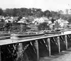 Traveling south across the Mohawk from Rexford, stone pilings in the river hint at the presence of something of a grander historical significance. Here is where the Erie Canal crossed the Mohawk on a large stone aqueduct. There's great collection of photos here of the aqueduct. It was a favorite subject for many postcards in its day,
Who would have known traveling through the small town that it was also home to the famous Luna Park? From 1906 until 1933, daredevils leaped from a tall tower, carousels, merry-go-rounds, roller coasters, airplane rides and all kinds of amusements buzzed with activity, making Rexford a hot spot to visit in the area. Check out this wonderful collection of photos to see for yourself just how much variety there was.
Another interesting item was the McLane Hotel, a stop for stagecoaches and canal boats. John McLane operated it until about 1930. An old-fashioned and extremely weathered building with large galleries on both floors and a cupola at its peak, the strange building was a mysterious curiosity to all who passed by. It was demolished in 1964.
There are still visible remnants of
Clifton Park
 How many of you recognize the Clifton Park Hotel? (northeast corner of Old Route 146 and Route 9, Clifton Park Village). I always wondered what this relic from the past was and hope that somehow it can stay preserved and find new use in the easy-come easy-go commercial craptraps surrounding it.
It's a shame but the old village has all but disappeared.
There was a large spice mill on the Farm-to-Market Road in Halfmoon, NY back around 1892 and a Blacksmith and Carriage Shop. I believe the church is still standing. The Town Historain has posted a detailed history of the Grooms Corners Tavern.
Glenville
- The Glenridge Hospital was originally built as a tuberculosis sanatorium in 1927. It is not only historically important as a rare example of a tuberculosis hospital still standing, but also as a structure built in the Spanish Eclectic architectural style, a style more likely to be seen in Florida and the southwest. Further Info
- East Glenville (at least the part near the corner of Glenridge Road and Rt. 50) was (and is!) known as Stoodley. Detail
- Before KAPL in Niskayuna, there was a G.E. experimental laboratory on Sacandaga Road. Mysterious remnants of the lab are sill standing... hidden in the woods. Details and photos
- On the north side of the Mohawk River, several hundred yards downstream of Lock 8, a buried prehistoric Indian village was uncovered. Flood waters cut into the bank of the river exposing fire hearths six to eight feet underground.
- The stately old vertical board-and-batten siding home (built approx 1850) located on the corner of Charlton Road and Van Vorst was the centerpiece of a broom corn farm and factory that made brooms. Photo
Scotia
Did You Know?
- Alexander Lindsay Glen, a native of Scotland, purchased from the Mohawk people in the 17th century and named his estate Scotia (Latin for "Scotland") after his home country.
- During the 1800s, Scotia was known for its production of brooms, over 1 million annually for a time. More Info
- There was once a place called Glenotia Park on—of course—Glenotia Island! Details: "For sale: an island"
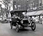
- Schenectady's Washington Ave continues thru Scotia (map) because it was once connected by a bridge. It had a streetcar railway as well as a roadway and tolls were collected. See the historical photo.
Schenectady
 Did You Know?
- The area that is now Schenectady was originally the land of the Mohawk tribe of the Iroquois Nation.
- When Dutch settlers arrived in the Hudson Valley in the middle of the 17th century, the Mohawk called the settlement at Fort Orange "Schau-naugh-ta-da", meaning "over the pine plains." Eventually, this word entered the lexicon of the Dutch settlers, but the meaning was reversed, and the name referred to the bend in the Mohawk River where the city lies today.
- The film "The Way We Were" was filmed on location in Schenectady at Union College, and in nearby Ballston Spa.
- In the antebellum years, Schenectady became a center of abolitionist activities. An Underground Railroad route ran through the area.
- In 1930, Proctors Theater hosted the first public demonstration of television with the help of General Electric.
- On the side of the Broadway exit of Interstate 890 lurks a mysterious concrete structure obscured by trees and vines. What city workers now call the "stairway to heaven" was once part of the Klondike Ramp, an eight-story circular walkway that carried General Electric workers to and from Hamilton Hill from the 1930s to 1958. Info and Photos
- More Schenectady Historical Info
Ballston Spa
 Did You Know?
- The village was first settled in 1771 and was incorporated as a village in 1807.
- Ballston Spa was once a flourishing resort community in the 1800s. It became one of America's premiere tourist destinations in the early 1800s due to the “healing” waters of several area natural mineral springs.
- In it's heyday, Ballston Spa's San Souci Hotel was the largest hotel in the United States and one of the largest hotels in the world. Presidents, senators and governors stayed there, as well as many wealthy private citizens.
- It was soon eclipsed by Saratoga due to a number of factors but mainly: "The springs that promised to be so valuable were lost, according to the story of the older people, by not 'letting well enough alone.' In the attempt to dig them over and retube them, the several veins were lost..."
- Ballston Spa is famous for being the birthplace of Abner Doubleday, who is credited for creating the game of baseball.
- James Fenimore Cooper wrote some of his legendary novel "Last of the Mohicans" while staying in the building that is now the Brookside Museum.
- Scenes from two popular movies "The Way We Were" (1973) and "The Horse Whisperer" (1998) were filmed in Ballston Spa
Links
- Historical Map
- The Old Chocolate Factory in Ballston Spa. Wikipedia Article
- The San Souci Hotel (Ballston Spa) Wikipedia| Photo
- An 1878 Historical Summation
Malta
 Did You Know?
- Malta got its name from a popular 18th century local malt brewery (hence the name “Malta”)?
- Is home to Luther Forest, one of the largest pine forest plantations in the northeastern U.S. This forest, which was originally just 110 acres, grew over time to include 7,000 acres.
- Thomas C. Luther (born in nearby Ballston Spa) created the Luther Forest as a managed forestry program in 1898.
- Malta town fathers like to call Luther Forest “the birthplace of NASA” as it was where research and testing for the Hermes Rocket Project occurred. Inside the 7,000-acre pine forest buffer zone, a secret 165-acre rocket motor laboratory existed where rocket test-stands were hidden and later ordinance was exploded. Further Details
- The earliest settlers were Loyalists and had to move during the Revolutionary War. The town of Malta was formed from Stillwater in March 3, 1802 and a portion of Saratoga was added on March 28, 1805. Read a 1878 document about Malta
Luther Forest Today...
- The Luther Forest is now the Luther Forest Technology Campus or LFTC, a 1,414-acre (573 hectares) site specifically designed for semiconductor and nanotechnology manufacturing and other innovative technologies. See Map. Still one of the most natural, picturesque and historic sections of Malta, the campus area has carefully balanced nature and technology setting aside areas for recreation and preserving much of the original dense forested ambiance.
- You can hike in the 100 Acres Park or mountain bike nearby in the STEP Trails.
Alplaus
 Did You Know?
- Alplaus means "Place of the Eels"? It is derived from the Dutch "Aal Plaats". Sign Photo
- The Alplaus Kill was a major throughfare for Native Americans. The Alplaus Trail
just use the browser's back button to take you back to this site.
Historical Maps
- The Motherlode :-)
University of New Hampshire's Library's Government Information Department held a working collection of over 55,000 paper USGS maps. This online collection of over 1,500 USGS topographic maps included complete geographical coverage of New England and New York from the 1890s to 1950s. It has now been moved to the Web Archive site: Saratoga, NY Quadrangle (1902, 1942 and 1949) - Library of Congress - American Memory Map Collection
